

Rhapta: a town in ancient Tanzania

In what is becoming an impromptu series, here is another thing I couldn’t get to fit in my next book! The site of Rhapta caught my imagination as soon I started to read about it, but there was not yet enough evidence and information to write a whole chapter about it in a way that would fit the overall book. So here is some information, much of which has been gleamed from the amazing work of Prof. Felix Chami. Many of his articles are freely available online and can be found if you click here.
The ancient world is often reduced to a very small map, one that covers little more than the Mediterranean basin. Indeed, if you think about it, maps of the ancient world often end up relying on the Roman Empire as its geographic template. This is of course nonsense, the ancient world was exactly that: the world. But you would be excused for thinking that the ancient Mediterranean was the be all and end all. That is certainly how it is presented to us.
This is not only untrue, it also underplays the fact that the Romans and Greeks before them were very aware that there was a big world out there. They just didn’t know how big.
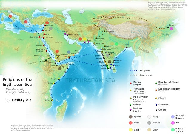
One place of particular interest was located to the south, on the east coast of Africa. In fact it was, to many of the ancient geographers, the most southern location in the known world. It was made up of two regions, Barbaria which was the interior, and Azania which was the name of the coastal region (Periplus of the Erythraean Sea, 18).
These markets of Azania are the very last of the continent that stretches down on the right hand from Berenice; for beyond these places the unexplored ocean curves around toward the west, and running along by the regions to the south of Aethiopia and Libya and Africa, it mingles with the western sea.
I love this passage because you really get a sense of the author’s knowledge running out - the land and sea goes on, but it is unexplored. This is not our only account, the lands of Azania are described in quite a few different sources dating from the Roman period. Many of which mention, in varying detail, an important market town in the region known as Rhapta.
Locating Rhapta
According to our evidence, Rhapta was a bustling port that was a particular good source for ivory, rhinoceros horn, coconut oil and tortoise shell. The name comes from the Greek word rhaptos meaning stitched or sown, apparently as a reference to the sewn boats that the locals used. According to one of our sources, Rhapta was a sizeable settlement and was described as a metropolis that was only a short distance from the sea (Ptolemy, Geography 4.7.12).
Our evidence for the town comes from authors who were interested in trying to give accurate geographic descriptions. Indeed, Periplus was written by an unknown author, but someone who clearly had a working knowledge of the trade routes that crossed the Indian Ocean and entered the Red Sea. So Rhapta has always been presumed to be a real place, and its position to be somewhere along the east African coast.
Many locations have been chosen as the site for Rhapta over the years, but perhaps the most promising one is in the delta of the Rufiji River in Tanzania, and the corresponding island of Mafia, which lies just off the coast. The location roughly maps onto the descriptions of our sources, including the relevant latitude given by Ptolemy. More excitingly, researchers have already uncovered evidence of ancient international trade in the region and more recently have identified what one scholar believes to be evidence of an ancient wall and buildings! To see a write up and photos from the archaeologist in question, Prof. Felix Chami, click here.
Annoyingly, there are no good images or videos that are free from copyright that can be posted here - I have yet to convince my family to take a trip! - so, instead, take a look at this website which has underwater photography and videos of the site: click here.
Life in Rhapta
Rhapta was predominantly inhabited by a Bantu-speaking people who are described in our sources as farmers and fishermen. When it comes to fishing, they are said to have had a unique style (Periplus of the Erythraean Sea, 15):
[T]hey also catch them [fish and tortoise] in a peculiar way, in wicker baskets, which the fasten across the channel-opening between the breakers.
While this passage does not specifically mention Rhapta - it is describing people living slightly north of the town - underwater studies at Chole Bay, which would have been in the Rufijji delta but is now part of the Mafia archipelago, have found fishing estates. These would have sat in the shallows of the delta and locals would have used basket-like traps, the types of which are are still being used to this day.
Rhapta was not entirely unique in the region in its design, we know of other nearby sites from this period that have walled enclosures made from mud and wattle. What makes Rhapta different is that its walls are made with stone and concrete in the manner of the Romans. Whether this means that the people of Rhapta adopted building methods from abroad, or that some Romans may have lived in the town has yet to be concluded, but either scenario is an exciting prospect for the global history of the ancient period.
It is worth stressing that it was not just the Romans who were present, in fact our evidence suggests that Rhapta was quite the cosmopolitan town with both residents and visitors from Arabia, south east Asia, and possibly even China!
As excavations continue at the site we may well see the uncovering of an amazing ancient story and the firm identification of Rhapta: the most southerly point of the known (ancient) world.